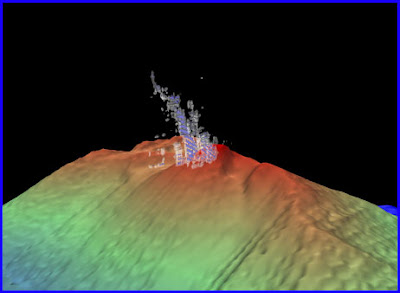
3-D view of the bubble plume rising 200 meters above the summit of NW Rota volcano. Image created using Fledermaus mid-water tool, with guidance from Maurice Doucet. The landslide scar is visible near the summit to the right (east) of the plume. |
CO2 bubbles rise from the plume of Styx Vent over NW Rota volcano. |
Our bathymetric mapping efforts at the Mariana arc have revealed the morphology of underwater volcanoes that were only imaged by satellite altimetry data at coarse resolution when we first visited here 7 years ago. On each of our expeditions we have added to our mapping database, collaborating with other institutes to better reveal the seafloor here at the Mariana arc. The highlight of the bathymetric mapping on this cruise was our ability to map the volcano when we arrived this year and compare it to the data we collected here last year. We could tell from differencing those datasets that there had been a major landslide event on the seafloor, even before we reached the bottom on our first Jason dive (see blog entry “The Landslide” map 1).
Map of some of the bathymetric data collected during expeditions to the Mariana Arc over the last 7 years. Data collected during this cruise, NWRota 2010, are outlined in black. Shallow water data near the islands (dark brown) and background data in grayscale are composed or various data sets synthesized by the Hawaii Coral Reef Ecosystem Division. |
Susan Merle
Oregon State University / NOAA Vents Program


