March 29, 2010

NWRota 2010 Cruise Summary

The 2010 expedition to NW Rota-1 submarine volcano was a great success, despite the challenges we faced at sea. We found that the volcano was still activity erupting even though it had experienced a major landslide since our previous visit a year ago.
Jason pilot Scott Hansen and Scientist Bob Embley monitor ROV Jason during a dive to one of the erupting vents at NW Rota. Explore the Jason control van with a Quicktime VR Panorama, courtesy of R/V Kilo Moana's Third Mate, Jim Scancella (also of virtual-venues.com). Click on link to load the panorama and click and drag your mouse to move around Jason's control center.
The landslide was a mixed blessing, because on the one hand it gave us a unprecedented view of how arc volcanoes grow by the cyclic process of eruption, collapse, and regrowth, how the volcano’s magmatic and hydrothermal systems responded to such a large perturbation, and how the resident chemosynthetic biological community was impacted.On the other hand, the landslide destroyed some of the instrument moorings that we left last year to monitor the volcano’s activity, and that is a major disappointment. We had hoped to capture just this kind of event, but this one turned out to be much larger than we thought possible. Still, we were able to recover one hydrophone mooring and will be examining the sound recordings it made shortly. It is safe to say that these processes have never been documented in such detail and we are sure to learn new things about submarine eruptions as well as large mass-wasting events and their impacts.
ROV Jason returns from the deep as it is lifted on to the deck of the R/V Kilo Moana

Special thanks to the captain and crew of the R/V Kilo Moana, the Jason ROV team, and the National Science Foundation for supporting our research!

-Bill Chadwick, Oregon State University

2010 NW Rota-1 Science Team:


(back row l-r):
Kevin Roe, Eric Olson, Bob Embley, Nathan Buck, Nick Deardorff, John Sherrin, Sharon Walker and Susan Merle

(center row):
Julie Smith, My Christensen

(front):
Dave Butterfield, Leigh Evans, Joe Resing, Verena Tunnicliffe, Bill Chadwick and Andra Bobbitt

Overcoming adversity

Sometimes things don’t turn out the way you plan, but you always have to make the best of what you have. We had planned to do a number of vertical casts and tows during this cruise with our CTD – an instrument system that measures the basic properties of seawater (conductivity, temperature and depth) with special sensors to detect the particle and chemical plumes coming from volcano, and several large bottles for collecting water samples. We wanted to map the extent of plumes from the eruption and measure their chemical impact to the surrounding ocean environment. Also, if there had been any recent landslides, there would probably be layers of turbid water deeper around the flanks of the volcano. But these plans were thwarted early in the cruise when the ship’s new crane and winch for handling the CTD developed problems that could not be repaired at sea. This was a very unfortunate setback.

CTD Instrument


However, when the going gets tough, the tough use MAPRs (an acronym for Miniature Autonomous Plume Recorder). MAPRs are small, self-contained instruments that can easily be attached to wires or lines of many sizes and have the same plume detecting sensors as the CTD. They do not have the rapid sample rate of the CTD, and they have no way to collect water samples, but the one MAPR we had on board did give us the opportunity to get at least some valuable information about the plumes over the volcano. Several MAPRs had been deployed on the moorings that were swept away by the landslide, so despite the volcano’s apparent appetite for MAPRs, we deployed the one we had as many times as we could. The versatile little MAPR was strapped to Medea for nearly every Jason dive, clamped to the line with every plankton net tow, and even deployed all alone at the end of the 700 meter line (the longest length of line we could come up with on board) with a 400 pound weight at the end. We even attached the small hydrophone to it to ride piggy-back for a few casts.


Data from the MAPR showing the plumes.


By being flexible and adaptive, we managed to create quite a few sampling opportunities. We were even able to repeat a line of casts south of the summit several times to show the short-term variability of the plume. While ROV dive observations showed just how variable and dynamic the conditions near the volcanic vents are, the MAPR profiles show both consistency and variability in the plume dispersing above the volcano.

One Jason dive went deep, downslope along the slide area to about 1850 m. The MAPR profile from this dive showed there were no lingering turbid layers around the flank of the volcano. This implies the landslide occurred long enough ago for the fine particles that were surely stirred up during that event to have either settled back to the seafloor or be carried away by local currents.

Despite the unexpected total loss of the use of our CTD, we are not coming home completely empty-handed.

This image shows a cross-section of the plume as defined by suspended particle concentration. A series of 5 locations south, and down-current of the eruptive vents, was sampled on four consecutive nights.


Photo of CTD on deck after a successful test cast at the very start of the cruise. Water was being rinsed through the bottles in preparation for the sampling program we anticipated.

MAPR being prepared for deployment with hydrophone attached.

Hydrophone strapped to the MAPR.


Sharon Walker
NOAA Pacific Marine Environmental Laboratory
Vents Program

March 28, 2010

The Bad Luck Honeybear

Sailors have always been notoriously superstitious at sea. And sometimes even scientists can be too. We have had more than our share of bad luck on this expedition, including problems with the ship’s CTD winch and crane, its bow-thruster, one of its deck winches, various electrical problems with the Jason ROV, and we lost some of our monitoring instruments that we put out last year to the landslide. When the problems have pile up, it has felt like we are cursed somehow - and we began to suspect our old nemesis - the honeybear.


Years ago, on another ship with another ROV, we were similarly plagued by equipment problems and bad luck. One of the crew members started a rumor that the honeybears in the ship’s mess (where we eat on board) were the cause of our bad luck. So to amuse ourselves in the time we had to wait as equipment was repaired, we devised various ways to torment and defeat the honeybear’s bad mojo. And somehow it actually seemed to help, our luck changed, equipment got fixed and we could get back to work.

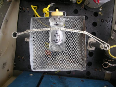
So when we were mired in bad luck again on this trip, someone noticed the Kilo Moana also had honeybears in the mess. We had to do something about it! We kidnapped one, strapped it to a shrimp trap (with a little note), and sent it down to the bottom on the next dive with Jason. Immediately, our luck changed - we found the missing hydrophone mooring on that dive, and things seemed to be going better. Then on the next Jason dive, we brought that shrimp trap (and the honeybear) back to the surface. On the way back up, Jason lost power due to a ground-fault on one of its transformers, which was a very serious problem. If the damage was too great, we might not be able to dive again - losing our last two dives with experiments still to recover from the bottom.
The honeybear’s evil mojo had obviously struck again! It was clear that we should never have brought him back to the surface - we should have left him on the seafloor where his mojo was crushed by the pressure and the volcano’s toxic fumes. As the Jason group worked tirelessly to repair the vehicle, I went out to the back deck, strapped that honeybear to a weight, and tossed him overboard. By morning, Jason was repaired and we were able to make our last dive at NW Rota.


I’m a scientist, so I don’t really believe that the honeybear had anything to do with our bad luck. But sometimes it’s fun to act on a wild theory and have someone or something to blame for all the things that are going wrong. At least it gave us a chance to laugh in the face of adversity and perhaps that alone helped a little. Or was it really bad mojo?

-Bill Chadwick, Oregon State University

A Brief History of NW Rota

When I began my career in oceanography 45 years ago I never dreamed I would ever be where I am today – sitting over an erupting volcano in the western Pacific.
Styx Vent does its part in supplying material for the growth of NW Rota-1.
Our long term study of this volcano began with the discovery of its gaseous volcanic plume in 2003 followed by the first dive to Brimstone Pit in 2004 when we realized we were the first human witnesses to a submarine eruption. At that time Brimstone was spewing gas clouds laden with molten sulfur and a small amount of ash. During subsequent dives in 2005 with the Japanese ROV Hyper-Dolphin and in 2006 using Jason, the activity increased with semi-continuous volcanic ash bursts and intense degassing with an occasional glimpse of red hot magma through the swirling sulfurous cloud. Last year Brimstone was slowly extruding spines of lava. This year we have found multiple vents with highly variable activity - no doubt due to the disturbance to the upper “plumbing system” resulting from the large landslide that occurred over the past year.
Rota Summit: Hydrophone, biologic experiment and marker precariously hold onto what’s left of the summit of NW Rota-1 at 518 meters. Black area is where Jason triggered small sediment slide when deploying instruments.


NW Rota is more or less a “typical” composite submarine volcano found along the Mariana volcanic arc. During its early growth in deep water eruptions produced primarily lava flows. Several smaller deeper submarine cones composed primarily of lava flows are found ~12 nautical miles (~20 km) east of NW Rota. As it grew shallower eruptive activity became more explosive as the pressure holding the gas dissolved in the magma lessened. This transition led to a gradual change in the form of the volcano because volcanic fragments such as ash and larger pieces can only build out to the “angle of repose” after which the material sloughs away into deeper water building out the flank of the volcano. We see this process on a small scale when Jason triggers slides in the newly deposited volcanic sand near the eruption sites. Yesterday we saw small scale mass movements at Styx vent when it suddenly became very active. In fact, the Jason was “shoved” away from the vent as material cascaded downslope in front of us. The large landslide that occurred here during the past year is part of this long term process of volcano construction.
Southern flank of NW Rota-1: White stained angular blocks on top of debris flow from summit litter slope near where we “heard” one of the lost moorings.


Some arc volcanoes undergo much more catastrophic events. A volcano called West Rota lying ~ 16 nautical miles (~30 km) SE of NW Rota had a very large eruption ~40,000 years ago when the entire top of the volcano was removed during an explosive eruption that formed a caldera (large crater) similar in size to Crater Lake in southern Oregon.


We have to appreciate that we are only looking at a short chapter in the life history of NW Rota. How long this “growth spurt” will last is anyone’s guess.


Bob Embley
NOAA Pacific Marine Environmental Laboratory
Vents Program

March 27, 2010

Eruption movies

Yesterday we got the clearest views yet of the explosive eruptive activity at NW Rota. We've now found 5 separate eruptive vents, all in a line within about 100 m. Some have opened up while we've been out here. The activity we've seen this year is a lot more variable than we've seen in the past. An eruptive vent will be active on one dive, then inactive on the next. Vents even open up and shut down from hour to hour. We don't really understand why, but suspect that the volcanic plumbing system was disturbed by the landslide and has not yet finished reorganizing itself.


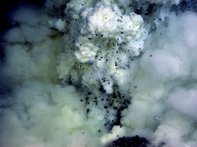
With each explosive burst rocks and ash are thrown up (making the plume dark), but quickly drop back to the seafloor (turning the plume white). The billowing white plume is full of tiny droplets of molten sulfur.


As the clouds from an explosive burst rise and expand, bubbles of CO2 float upward in front of Jason. Plumes of such bubbles are what we've been seeing with the Kilo Moana's new sonar system (see Volcano Mapping post).


Because the pressure at this depth dampens the power of the explosions, Jason can approach within a few feet of the eruptive vent (notice the Jason basket in the foreground at the beginning of this clip). However, in this case the volcano got a little too active and Jason had to back away temporarily. Notice how the eruptive plume expands and contracts during the biggest bursts.

-Bill Chadwick, Oregon State University

All video copyright by Advanced Imaging and Visualization Lab WHOI

Something Old, Something New

When we first met the shrimp of NW Rota in 2004 we wondered what makes them so special that they can thrive in such a volatile environment. Last year both species, Opaepele loihi and an undescribed Alvinocaris species, had expanded their distributions and seemed to be doing quite well for themselves. Hydrothermal vents with bacterial mats were plentiful and there were plenty of shrimp around to take advantage of the favourable conditions. There , were a large number of adults of both species and where one species was found, the other was almost surely there. Alas all good things must come to an end, or in the case of NW Rota a new beginning.
Figure 1- A steep cliff face covered with Opaepele loihi shrimp.
The major landslide that occurred at Rota has given us some excellent clues as to how a major disturbance affects a community dominated by mobile vent organisms and how new habitats on an erupting volcano are colonized by shrimp. There are few remaining habitats from last year and the newly disturbed parts of the volcano have already been colonized by vast numbers of new recruits. The extent of this colonization in less than a year is astounding with thousands of juvenile shrimp in areas newly exposed by the slide.
Even more surprising is that this new crop of shrimp appears to contain just a single shrimp species, Opaepele loihi. This “volcano specialist” is well adapted to living on erupting submarine volcanoes, found at 4 thus far, but we still know nothing about how it survives the harsh conditions or how it finds and colonizes new habitats. By comparing the new populations at NW Rota with populations from previous years and by collecting shrimp larvae in plankton hauls around the seamount we hope to uncover how these shrimp recruit to NW Rota. The Alvinocaris shrimp are notably absent in the slide-affected region yet they remain a part of the vent community in unaffected habitats.
Figure 2- An adult Alvinocaris shrimp stands proud among the smaller “loihi” shrimp.
Both species of shrimp feed by grazing on bacterial mat throughout some or all of their post-larval life. The “loihi” shrimp have specialized claws like garden shears for clipping bacterial mat which allows them to do so very efficiently while the Alvinocaris shrimp also graze mat but transition into scavengers and predators as they get larger. One of our goals this year is to compare bacterial mat samples from areas with and without shrimp. By finding out what they like to eat and comparing this with where they are and the fluid chemistry at different vents we can better understand what makes a suitable habitat for these amazing shrimp.

John Sherrin
University of Victoria

Volcano Mapping

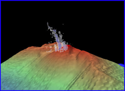
The R/V Kilo Moana has just recently installed a state of the art multibeam system with not only the capability of mapping the seafloor, but also technology for simultaneous high resolution mapping of the water column. The water column data have made it possible for us to map the bubbles that are rising from the eruptive vents at the summit of NW Rota volcano, which are mostly-CO2.

3-D view of the bubble plume rising 200 meters above the summit of NW Rota volcano. Image created using Fledermaus mid-water tool, with guidance from Maurice Doucet. The landslide scar is visible near the summit to the right (east) of the plume.
During our Jason dives we have observed the bubbles ascending from the vents on the seafloor generated by de-gassing of the magma beneath the volcano summit. We now can get an estimate of the rise height of those bubbles in the water column, as well as a three-dimensional view of the bubble plume.

CO2 bubbles rise from the plume of Styx Vent over NW Rota volcano.

Our bathymetric mapping efforts at the Mariana arc have revealed the morphology of underwater volcanoes that were only imaged by satellite altimetry data at coarse resolution when we first visited here 7 years ago. On each of our expeditions we have added to our mapping database, collaborating with other institutes to better reveal the seafloor here at the Mariana arc. The highlight of the bathymetric mapping on this cruise was our ability to map the volcano when we arrived this year and compare it to the data we collected here last year. We could tell from differencing those datasets that there had been a major landslide event on the seafloor, even before we reached the bottom on our first Jason dive (see blog entry “The Landslide” map 1).

Map of some of the bathymetric data collected during expeditions to the Mariana Arc over the last 7 years. Data collected during this cruise, NWRota 2010, are outlined in black. Shallow water data near the islands (dark brown) and background data in grayscale are composed or various data sets synthesized by the Hawaii Coral Reef Ecosystem Division.

Susan Merle
Oregon State University / NOAA Vents Program

March 25, 2010

Eyewitness to the Landslide

Today, we successfully recovered the hydrophone mooring that we deployed last year at NW Rota to record the sounds of eruptive or landslide activity. We had not been able to communicate with the mooring since we arrived this year, so we feared it had maybe been swept away by the landslide. We didn’t know if it was still there or not. Today, we decided to find out by driving to its deployment location with Jason. We were able to quickly find it with Jason’s sonar and confirmed that it was still intact. Fortunately, it was located well north of the new landslide scar and so survived the event. After finding it, we sent the release code from the ship while Jason watched on the bottom, the release function worked, the mooring floated to the surface, and the ship recovered Jason and then the mooring including the hydrophone.

ROV Jason II witnessesd the release of the hydrophone mooring as the signal was sent from the ship to the release device pictured on the left. In the next instance, the hydrophone mooring was released to the surface and only bubbles from the wake remained (right image).

It's a relief to get the hydrophone back after not knowing if it survived the landslide. It will be a few weeks before the data are examined and analyzed, but it surely will be a fascinating record because it can tell us when the landslide occurred and how it was related to NW Rota's eruptive activity. This is probably the first ever near-field recording of a landslide on a submarine volcano, and it will help us better understand a lot of what we are seeing on the bottom this year with Jason.


The actual hydrophone instrument was pulled on board the R/V Kilo Moana after being released from the ocean floor. The hydrophone should contain data documenting the landslide event.


-Bill Chadwick, Oregon State University.

Teetering on the Brink

Life on a active volcano is anything but boring; food can be bountiful but the hazards are legion. NW Rota presents some unusual challenges for the animals that colonize the vents. The sulphur-rich system supports abundant chemosynthetic production by bacteria, often forming extensive mats around areas where hydrothermal fluids emerge. For a larva settling from the water, these sites must seem a great choice for a new home. Over the past years, we have not encountered many species at NW Rota but inhabitants are often abundant: shrimp, limpets, barnacles and crabs. Lately, however, the new homestead appears to have a few problems!

The red laser dots on this sulphur crust are 10 cm apart. The small specks are hundreds of juvenile shrimp recently recruited to the volcano.

NW Rota has undergone a major reorganization as the eruptive cone grew and a large piece of the summit collapsed downslope – taking with it prime habitat. We have not located many sites of vigorous venting remaining. Last year, limpets had spread across the summit and a barnacle (a new species) had established several colonies. However, most of those animals rode the collapse into the depths – we have found only one small refuge of barnacles (so far). The limpets are hanging on – lots of egg cases where there are a few adults left and a recent recruitment of small limpets. This animal is also a new species – so far we have not seen it on any other Mariana Arc volcano although an allied species inhabits the northern Arc.

Last year, we observed the white vent crab at every site on NW Rota. It is an adaptable animal that appears to graze on bacteria but will also grab shrimp and smaller individuals of its own species. We have yet to see more than 10 individuals this year. The most impressive of the NW Rota species is a shrimp that we have seen in large numbers every visit to the volcano. Opaepele loihi seems to be a volcano specialist – it is now known from four sites of recent/ongoing eruptions. It is well adapted to grazing on bacterial filaments around vents – both hydrothermal and volcanic. We were surprised to find huge numbers of this animal on the volcano – they are very small so must have settled quite recently.
A small refugium for barnacles. The pink scaleworm is a predator and the small white dots are limpet egg cases.

Survival is linked to how well these animals can maintain their populations in this highly unstable habitat. Mostly, this feat is accomplished through reproduction. The neritid limpets foster the first part of development of their young in egg sacs but larvae hatch into a swimming phase around the seamount. Part of our objective here is to search for the larvae of shrimp with plankton net hauls from the ship; we hope to find new recruits ready to settle onto this island of food – perhaps only to disappear in the next eruptive event.


Verena Tunnicliffe
Professor, University of Victoria
Director, VENUS Subsea Observatory

March 24, 2010

NW Rota Image Gallery

Images from NW Rota Volcano, March 2010:

Shrimp congregate in areas of lower-temperature, hydrothermal fluids:


Volcanic ash is erupted from the plume over the active vent Phantom near the summit of NW Rota:

At the summit rim, a navigation beacon marks the location of a hydrophone listening to the eruptions, a shrimp trap and a tephra (volcanic ash) collector above the erupting vent.


New boulders of lava sit within the center of the venting Phantom.


JASON Team prepares the ROV for departure to the volcano.
The front of the vehicle has 2 arms capable of handlingthe scientific equipment and cameras are strategically placedfor in front and back for viewing.

March 21, 2010

The Landslide

Ash-covered, steep, unstable slopes around the volcano.


We had previously found evidence for the repeated build-up and collapse of the ash and lava around Brimstone vent at NW Rota, leading to landsliding down the steep southern flank. To try to capture these kinds of events, last year we deployed 4 moorings with temperature and turbidity sensors, current meters, a fluid sampler, and a hydrophone to monitor activity at the volcano between then and now.

In fact, we have discovered on this trip that the volcano experienced a major landslide between last year and this year. Such an event is exactly what we had hoped to capture, except that this one was far larger than anything we had anticipated and appears to have caught all four of the instrument moorings. After an extensive search, we have only been able to communicate from one of the moorings. This one was deployed downslope from the summit at a depth of 1500 m, and it was moved about 1 km downslope (to ~1830 m) by the landslide and the acoustic release reports that it is horizontal. We plan to make a Jason dive on this mooring to see what instruments survived and might be recovered. The data it recorded could be fascinating, but it is deeply disappointing that the other moorings appear to be lost, both for the loss of valuable equipment but also for the lost scientific data. We plan to search with Jason for all of them during subsequent dives, so we have not yet given up all hope of finding them.

Map 1:
By comparing the bathymetry we collected last year to data we collected this year, we can see major depth changes (see map 1). The landslide caused up to 100 m of depth change in the slide headwalls near the summit (blue areas on the map). Downslope of this scour are landslide deposits up to 40 m thick (red areas on the map) extending about 8 km from the summit and down to a depth of at least 2800 m. This landslide is at least an order of magnitude larger than anything we've seen in the last 7 years, and perhaps several orders of magnitude larger. It's huge. The red dots on the first map were the original mooring locations and the blue star is where we have located the 1500-m mooring (~1 km downslope). Amazing.

The changes in the summit area are equally staggering. The volcano summit is still in the same place and at the same height (probably a resistant lava plug), but the landslide event eroded back the summit ridge about 100 m to the north on either side, and one of the ridges SE of the summit has been replaced by a large landslide scar (on the 2nd map, the red line is the new summit ridge and the green dots are the mooring locations).
Map 2:
The lava cone that had built up last year at Brimstone vent was removed by the slide, and a new smaller lava cone is building up in its place. Brimstone vent is in the sample location, but is 25 m deeper, and we now we have found two other actively erupting vents within 50 m. Most of the hydrothermal vent sites we visited last year have been wiped out, but a few survived, and new ones have replaced the old. The biological community at the volcano summit has been severely impacted by the landslide. Amazingly, the two species of shrimp are still hanging on, although one species is now much more abundant than the other and there seems to be far more juveniles than adults. The limpets and barnacles (both new species only found here) that we saw last year have almost been wiped out. Also, there are far fewer areas of microbial mat. Life is tough at an active volcano!

-Bill Chadwick, Oregon State University

March 18, 2010

Arrival at Brimstone

March 18, 2010

We arrived at NW Rota seamount late yesterday and the question on
everyone’s mind was “would it still be erupting?” On the one hand,
the volcano has been found to be active every time it’s been visited
over the last 7 years, but on the other hand, how long could the
volcano keep this up? After we arrived, the first thing we did was
resurvey the summit of the volcano with the ship’s multibeam sonar
system, and the bathymetry showed some major morphologic changes
around the summit since last year. Next, we performed a vertical
cast with the CTD (an instrument package that measures conductivity,
temperature, depth, and optical backscatter) to look for evidence of
hydrothermal activity, and it showed that there was a strong plume
over the seamount. We’re now in the middle of making our first Jason
dive at NW Rota, and we’re seeing some big changes on the seafloor


2010 Brimstone at NW Rota-1 Volcano, Mariana Arc
since last year. First of all, the volcano is still erupting, which
I must admit still amazes me. Ash is being vigorously thrown out of
the vent along with a billowing sulfur-laden plume. But to our
surprise, we found 2 eruptive vents instead of 1. Also, the
submarine landscape is completely altered since last year. The main
eruptive vent is 25 m deeper than last year, and there appears to
have been both major landsliding (removing the large cone we saw last
year and parts of the surrounding area) followed volcanic re-
construction (which is gradually building a new cone over the
eruptive vent). What a dynamic landscape this is!
Every year we
have seen something different, which gives us the rare opportunity to
learn about how active submarine volcanoes work. We’re all excited
to learn more about what the volcano is up to this year. Stay tuned…

- Bill Chadwick, Chief Scientist, Oregon State University

March 8, 2010

Cruise Plan


2009 view of Brimstone Pit at NW Rota 1. Bucket was used to collect tephra (ash) spewing from the erupting volcano.


We are heading back to NW Rota-1, a submarine volcano that has been found to be actively erupting every time it has been visited since 2003. In fact, this is only one of two sites in the world where deep underwater eruptions have been directly observed (the eruptive vent is at a depth of 520 meters or 1700 feet). With support from the US National Science Foundation, we are taking advantage of this incredible opportunity to learn more about how submarine eruptions work and how they effect the ocean environment. For example, there are hydrothermal vent animals that live on top of the volcano in the midst of these eruptions and we’re very interested in how the eruptive activity affects the animals. During this expedition (March 16-30, 2010), we will be making dives with the remotely operated vehicle Jason from the research vessel Kilo Moana to make visual observations, collect samples, and deploy and recover instruments. What will we find this year? We don’t know, but we hope you will follow along to find out!

- Bill Chadwick, Chief Scientist, Oregon State University


Ship leaves Guam on March 16, 2010.
Returns to Guam on March 30, 2010.